East Hampton (CDP), Connecticut
Appearance
East Hampton, Connecticut | |
|---|---|
 The East Hampton Bank and Trust Co. | |
| Coordinates: 41°34′32″N 72°30′8″W / 41.57556°N 72.50222°W | |
| Country | |
| State | Connecticut |
| County | Middlesex |
| Town | East Hampton |
| Area | |
• Total | 10.54 km2 (4.07 sq mi) |
| • Land | 10.49 km2 (4.05 sq mi) |
| • Water | 0.05 km2 (0.02 sq mi) |
| Elevation | 121 m (398 ft) |
| Population | |
• Total | 2,960 |
| • Density | 282.2/km2 (731/sq mi) |
| Time zone | UTC-5 (Eastern (EST)) |
| • Summer (DST) | UTC-4 (EDT) |
| ZIP Code | 06424 |
| Area code(s) | 860/959 |
| FIPS code | 09-22420 |
| GNIS feature ID | 2377817[2] |
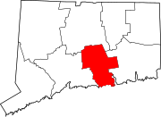
East Hampton is a census-designated place (CDP) comprising the primary village and adjacent residential and rural land in the town of East Hampton, Middlesex County, Connecticut, United States. It is in the central and eastern portions of the town, bordered to the north by the East Hampton community of Lake Pocotopaug and to the east by the town of Colchester in New London County and the town of Marlborough in Hartford County. As of the 2020 census, the East Hampton CDP had a population of 2,960,[3] out of 12,717 in the entire town of East Hampton.[3]
References
[edit]- ^ "2022 U.S. Gazetteer Files: Connecticut". United States Census Bureau. Retrieved December 12, 2022.
- ^ a b "East Hampton Census Designated Place". Geographic Names Information System. United States Geological Survey, United States Department of the Interior.
- ^ a b c "P1. Race – East Hampton CDP, Connecticut: 2020 DEC Redistricting Data (PL 94-171)". U.S. Census Bureau. Retrieved December 12, 2022.


